| Origin & Development | |
|
Legends & Fairy tales • Earth's Crust Thickness • Underwater Relief • Landscapes • History & Formation • Seismic Activity • | |
| History of Lake Baikal | |
|
History of Explorations • Inhabitants & Settlers • First maps of Baikal • Archaeological Sites • | |
| Lake Baikal Climate | |
|
Introduction • Fogs • Winds & Waves • Ice Conditions • | |
| Fauna & Vegetation | |
|
Mammals • Baikal seal - Nerpa • Ichthyofauna • Invertebrates • Vegetation • | |
| Water of Lake Baikal | |
|
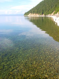
Colour • Transparency • Temperature • Pressure • Depth • Currents • Budget • Chemical Composition • Pollution • | |
| Recreational Areas | |
|
Circumbaikal Railway • Peschanaya Bays • Olkhon Island • Chivirkuysky Gulf • Wooden Irkutsk • Trans-Siberian Railway • | |
| People of Lake Baikal | |
|
People of Siberia • Buryat nation in Baikal • Russians in Baikal • | |
|
| |
| The face of Baikal - Water © A description of Baikal's water & questions concerning its pollution by S.A.Gurulev Temperature of Lake Baikal Water
Low heat conductivity is typical of water which gives off heat very slowly. Another peculiarity is the fact that it achieves its greatest density at +4°C. This peculiarity is the main reason for the spring and summer warming of the surface layer of water down to about 300 metres. Dense waters at +4°C sink and mix with cold waters, gradually evening off the temperature in the surface layer. In June the lake goes through a homothermic period (from the Greek 'homos' - the same, equal), which is a levelling out of temperature in the top 300 metre layer. During the state of homothermy, the temperature of the water in the top 300 metre layer gradually rises. In June a period of temperature stratification occurs, there arises a thin, well warmed surface layer separated from deep waters by a temperature jump layer below which the water temperature gradually decreases. In September Baikal's waters begin to cool and in November they again go through a state of homothermy, the autumn one. So the top 300 metre layer has two characteristic states, summer and winter. If in summer the water temperature gradually decreases with depth, in winter, on the contrary, it increases, from zero (and below) at the surface, immediately under the ice, to a level of about +3.5 +3.8°C at a depth of 200 - 250 metres. The top 250 - 300 metre layer of water with its temperature fluctuations is the habitat of the vast majority of animal and plant populations of the lake. Below the active layer is a body of water that has a small role to play in temperature exchange with the atmosphere. This is a body of darkness, where no sunlight penetrates. It is characterized by a relatively even temperature, which goes down to +3.1 +3.4°C towards the bottom. Nevertheless, the influence of climate fluctuations reaches even here, causing small, but nonetheless noticeable changes of temperature within a year and from year to year. As a result of the low heat conductivity of water, at a depth of one and a half kilometres the mass of water maintains a low temperature. Adjacent to Baikal, at the same depth, rocks, with a higher heat conductivity than water, have a temperature of +50°C. The cold of Baikal's watery belly has a significant influence on the temperature of the rocky bed of the lake. In those places where the bed is frozen, the water helps to maintain the minus temperatures; in other places where warm streams or hot springs rise from the depths, Baikal's water neutralizes this warmth. The warmth rising from the depths of the earth raises the temperature of the bottom layers by no more than one tenth of a degree. In general, it is thought that Baikal's water mass has a cooling effect on its rocky bed. Back in the 1930s the hydrologist N.N.Korytoikova calculated the temperature of the rocks beneath Baikal and found it to be lower than that at the same depth but at some distance from the lake. In principle, these calculations have been confirmed by present day investigators. The temperature regime of the bottom layers in Baikal is disturbed by the escape of deep thermal waters which mix with the relatively cold waters of the lake. However, there is no significant rise in the temperature here because of the mixing of these waters, as a result of which the warm input is dispersed in the body of water. Thermal water vents have been registered during investigations into warm deep water streams. Such a study has been carried out over many years by a researcher into Baikal's depths, the Irkutsk scientist V.A.Golubev. He studies warm streams with the help of temperature sensors let down from boats into the silts of the lake and into the deepest bottom layers of water. Golubev has found that deep thermal waters rise along definite zones, most probably along faults and cracks in the rocks. A centre for deep thermal waters under the belly of Baikal was first discovered in 1976 in Frolikha bay (North Baikal). Later, underwater springs were found at the outlet of the valleys of the rivers Bireya, Tompuda, Shegnanda, and Bol'shaya Rechka. Small increases in temperature at the very bottom have been registered here by direct measurements: from 0.02 to 0.15°C. Thermal water vents have been found at depths of from 220 to 420 metres. It is estimated that they cover an area of from 1 to 3 square kilometres. They are spatially limited to underwater canyons. It should be added that deep thermal water vents occur along the shores of North Baikal, on the shore itself, which are linked with faults in the earth's crust. These include the Kotelnikovsky, Khakusy, Davsha and other springs. Deep thermal water vents have also been discovered under water along the western shore of North Baikal in the Kukuisky canyon and at the Posol'sky sandbank, near the mouth of the Selenga. The temperature of the thermal waters rising from the floor of Baikal can be as much as +50°C, according to calculations, but the volume of these underwater springs is usually small. |