| Origin & Development | |
|
Legends & Fairy tales • Earth's Crust Thickness • Underwater Relief • Landscapes • History & Formation • Seismic Activity • | |
| History of Lake Baikal | |
|
History of Explorations • Inhabitants & Settlers • First maps of Baikal • Archaeological Sites • | |
| Lake Baikal Climate | |
|
Introduction • Fogs • Winds & Waves • Ice Conditions • | |
| Fauna & Vegetation | |
|
Mammals • Baikal seal - Nerpa • Ichthyofauna • Invertebrates • Vegetation • | |
| Water of Lake Baikal | |
|
Colour • Transparency • Temperature • Pressure • Depth • Currents • Budget • Chemical Composition • Pollution • | |
| Recreational Areas | |
|
Circumbaikal Railway • Peschanaya Bays • Olkhon Island • Chivirkuysky Gulf • Wooden Irkutsk • Trans-Siberian Railway • | |
| People of Lake Baikal | |
|
People of Siberia • Buryat nation in Baikal • Russians in Baikal • | |
|
| |
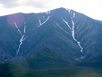
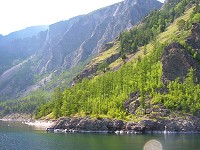
| Exogenous Relief Forming Processes There are four different natural landscapes prevalent on the territory of Pribaikalye: high-elevation, mid-elevation, low-elevation and plain.
EXOGENOUS Relief Forming Processes of Baikal Basin Bald Alpine Mountain Zone (1100 - 2800 m): Destruction of the intensively weathering rocks surface: 2 mm/year Identical by form and size rocks move along a 30° slope: 0.3 - 34 cm/year Snow avalanches (size: length 70 - 80 m; width 50 - 55 m; thickness 2 - 2.5 m) carry out sandy loams, grasses of rock debris and blocks (aprox.) to 30m3 Expenditure of temporary torrents: 3 - 4 m3/s Mass movement on 1 m thick layer of soils: 0.9 - 4.5 cm/year The area of semi-covering glaciers of Middle Pleistocene > 10,000 km2 Thickness of mountain-valley glaciers > 1000 m Forrest Zone (from the shoreline to 1100 - 1700 m): Rocky, heavily weathered outcrops of crystalline rocks are destroyed at 0 - 26 mm/year in zones of tectonic cracks up to 57 - 87,6 mm/years Chemical denudation: 0,002 - 0,025 mm/year Velocity of soil movement along the slopes of 30-45° at the depths of 17 - 31 cm: 1.4 - 32 mm/year The movement of rock-streams along the slops of 35°: 53 cm/year When the mudflow, lateral erosion of rivers reaches 7 - 8 m per 4 - 5 days Abrasion velocity of Baikal's shores: 0,88 m/year Movement of the sand to the sand to the forest on the shores: 2 - 15 cm/year Speed of sand replacement on the glades up to 10 m/year Sand blowing on Olkhon Island: 8.8 cm/year Steppes and forest-steppes: Soil replacement on the slopes of 20°: up to 0.8 mm/year Blocks laying on the surface of the slopes of 30° move: up to 105 cm/year | |||